We have had an incredible start to the snow season here in the Front Range Foothills of northeastern Colorado. Through the end of November, I have measured 59.2 inches of snow here at our home 4 miles east of Nederland, Colorado. This eclipses any other September through November period in my 10 years worth of records. The next highest total was from last year when we had 39.6 inches for meteorological autumn (September, October, November). Here is a break down for each of the years we have lived here:
| Year | Snowfall |
|---|---|
| 2019 | 59.2 |
| 2018 | 39.6 |
| 2011 | 32 |
| 2017 | 27.9 |
| 2015 | 21.6 |
| 2013 | 16.9 |
| 2014 | 12.9 |
| 2012 | 11.8 |
| 2010 | 10.2 |
| 2016 | 8.4 |
10 years worth of data is hardly enough to draw inferences from (according to the National Weather Service, a climatology requires at least 30 years of data). Still, based on my data, it is interesting to try to find a correlation between a snowy fall and a snowy winter. Here is how that breaks down:
| Year | Fall Snowfall | Total Season Snowfall |
|---|---|---|
| 2018 | 39.6 | 154.4 |
| 2011 | 32 | 159.9 |
| 2017 | 27.9 | 110.8 |
| 2015 | 21.6 | 193 |
| 2013 | 16.9 | 151 |
| 2014 | 12.9 | 150 |
| 2012 | 11.8 | 162.4 |
| 2010 | 10.2 | 114.5 |
| 2016 | 8.4 | 143.8 |
Keeping in mind that our average fall snowfall (not including this year because we do not know the total season snowfall yet) is 20.1 inches, then 3 in 4 years (or 75%) with above normal fall snow totals also see normal to above normal snow totals for the entire season. This may simply be due to that fact that our snow season is relatively long and a good start in the fall usually means we do well for the entire season.
November itself featured 32.1 inches of snow, which is well above the normal 15.1 inches. Our average temperature for the month was 31.3 F, which is 2.1 degrees F below the normal 33.4 F. Our highest temperature was 60 F on 11/9 while our lowest temperature was -2 F on 11/27. Our largest one day precipitation total was 0.94 inches liquid on 11/26. This corresponded to 17.3 inches of new snow for that day. Our biggest storm total snowfall was 23.8 inches from 11/25-26. This was by far the largest snowfall I have ever recorded for November (but remember I only have 10 years of data – so far).
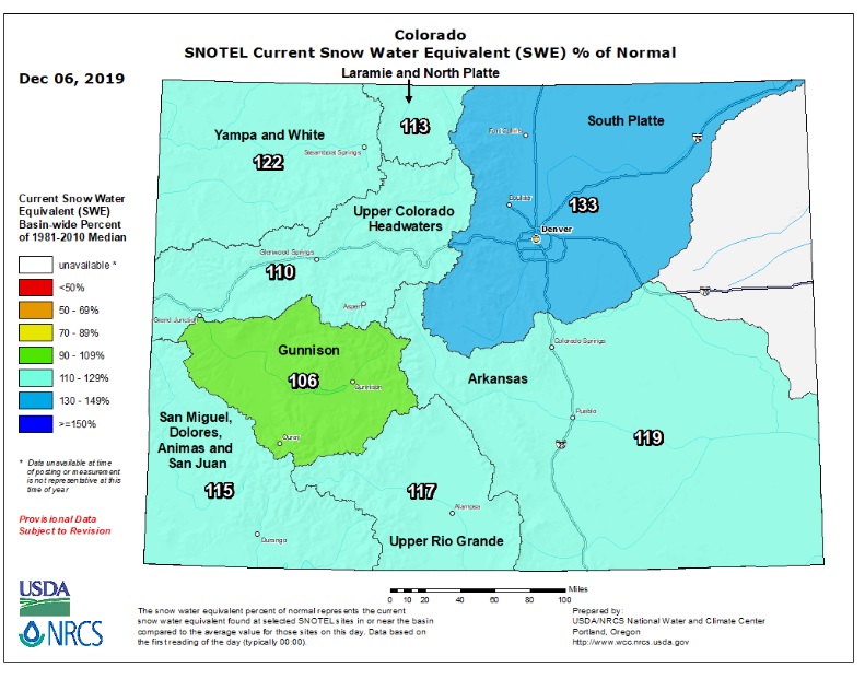
So far, the snow pack is looking pretty good across Colorado. The NRCS Colorado basin averaged snow water equivalent (SWE) map shows all basins with above normal values. The South Platte River Basin (the one Nederland and the surrounding Foothills communities are in) rings in with 133% of normal!
This is great news, but the snow season is still young. A lot can happen between now and May when the mountain snow pack typically starts to melt off.
Saturday appears to be a sunny and dry day for Nederland and the surrounding foothills communities with temperatures climbing into the low to mid 40sF! Enjoy the start of your weekend.