Spring is rapidly approaching, but as often seems to be the case in in early March in Nederland, the weather will be anything but frozen. Our trend towards milder weather this past week will continue on Saturday and Sunday with temperatures soaring into the low 50s F in Nederland and the surrounding Foothills communities. Anything frozen in and around the Front Range Foothills will be experiencing a big thaw. The reason for the milder temperatures is a large ridge of high pressure in the mid levels of the atmosphere. Ridges are normally associated with warm temperatures while troughs are accompanied by cooler temperatures. Ridges also tend to push the storm track to our north keeping conditions dry and the sky relatively clear. They are typically accompanied by lighter winds even in the mountains. On Saturday, winds in and around the Indian Peaks should be in the 15 to 20 mph range which is actually bearable for early March.
The ridge begins to push to our east and flatten later on Saturday and on Sunday. This will result in lowering heights and cooling temperatures to start the new week. The GFS model is also hinting at a weak disturbance bringing some moisture and precipitation to our area Sunday night. Temperatures would be borderline for frozen precipitation with snow levels setting up around 7000 feet. This does not appear to be significant event, and any snow that does fall should quickly melt. Temperatures will remain mild through much of next week with now big storms in sight.
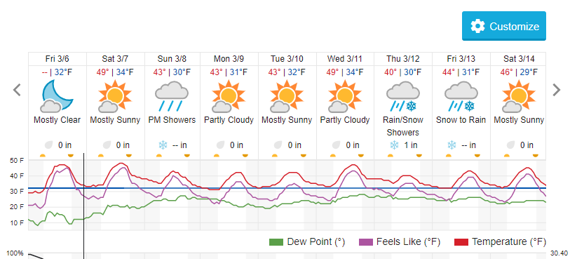
Here is the Weather Underground forecast for Nederland:
Enjoy this warm weekend in Ned !