The 6-10 and 8-14 day forecasts over the past week have been indicating a cooler and wetter trend in the weather, particularly over the western United States. We will begin to feel the affect of this atmospheric pattern change this week, and it appears like it will continue into next week, putting an abrupt end to our early taste of summer. Prolonged periods of hot, cold, wet, or dry weather are usually the result of blocking patterns in the atmosphere, especially in the fall, winter, and spring. This is the time of year that the polar jet stream is the strongest, and atmospheric blocks affect where the jet stream is positioned relative to Colorado.
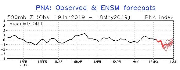
Meteorologists look at different atmospheric indexes when trying to assess the existence of blocking. This is especially important in winter weather forecasting. If a trough of low pressure becomes entrenched over the eastern United States in January, that can mean much colder temperatures and above normal snowfall over some of the largest population centers in our country. One of the indexes they look at is the PNA (Pacific North America) index. This is a good indicator of persistent weather patterns across North America. A positive PNA value usually means colder and wetter weather in the Eastern US and warmer and drier conditions in the West. A negative PNA value normally results in wetter and colder weather in the West while it is warmer and drier in the East.
After you have followed weather long enough, you begin to realize that often the western and eastern parts of our country have opposite weather conditions – if it is hot in the West it is cooler in the East and vice versa. The latest PNA forecast shows a distinct negative trend in the PNA pattern over the next week or so:
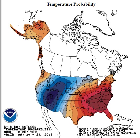
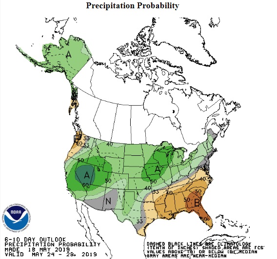
This corresponds well to the Climate Prediction Center’s 6-10 and 8-14 day outlooks for above normal chances of cooler and wetter weather in the West:
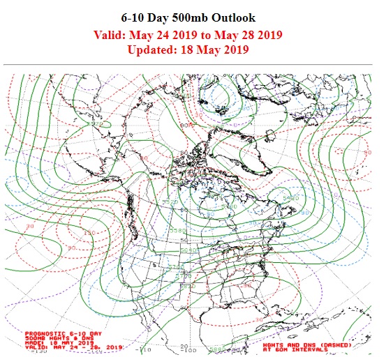
The Climate Prediction Center’s 500mb anomaly chart shows lower than normal heights (a trough) over the West with a warm ridge anchored over the East:
The upshot of a trough in the West is unsettled weather in Colorado. As usual, the computer models have been struggling mightily with the details of this weather pattern. The latest model guidance is showing a prolonged period of precipitation on Monday and Tuesday. Temperature profiles differ between the models. The North American Model (NAM) is much colder meaning that a majority of this precipitation will fall as snow in the Front Range Foothills communities. The GFS is warmer meaning more rain and less snow for us. Snow accumulations are always hard to nail down in May. The sun “strength” (the technical term for this is insolation) is the same as it is in July, and the days are long and the ground is warm. I think we’ll have a better feel for this forecast on Sunday night, but suffice it to say that Monday and Tuesday will be cold and wet. You will need to fire up that wood stove again!