141.6 is where we are at for snowfall so far this season here in Nederland, Colorado. Our annual average is around 153 inches. Now April is one of our snowiest months with an average of around 30 inches with May coming in around 14 inches. There are no guarantees, but if past years are any indication, there are probably a few more snow storms left for us this year.
Friday’s snowstorm was well behaved leaving exactly 5 inches of new snow here at our house. My forecast was for 3 to 7 inches, and the storm played out pretty much as expected. Early Friday morning, the GFS model was hinting that the storm would track closer to the Front Range Mountains which could have resulted in higher accumulations, but in the end the system tracked further to the east over Western Kansas.
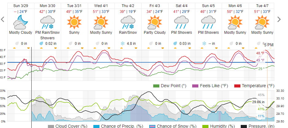
We have a couple of weather makers to keep an eye on this week. The first one will pass over Colorado on Monday. This system will produce some clouds and some scattered snow showers here in the Foothills, but with temperatures at or above freezing, there will be little if any accumulations, and impacts should be small. The next system will visit us on Thursday. This is still a few days out, but it looks like a strong cold front will sag southward across Colorado Thursday morning, and a 12 hour period of post frontal upslope flow will produce snow in Nederland, Ward, Rollinsville, and Black Hawk. This does not appear to be a big storm, but it could add another 3 to 6 inches of snow to our seasonal total.
Otherwise, Tuesday and Wednesday of this week look super with highs topping our near 50 F both days!
Here is the Weather Underground forecast: