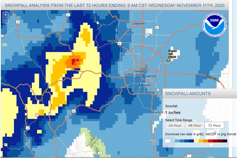
As expected, Monday brought some snow to Nederland and the surrounding Foothills communities. However, the snow amounts were a bit higher than what was in my forecast. I measured 4.5 inches here at our home with totals between 4 to 6 inches common from about Ward south to Rollinsville. The Snowfall map from the National Weather Service shows western Boulder County in the 4 to 6 inch range with a bulls eye of 18 inches just on the west side of the Divide near Winterpark:
Of course, the winds blew in Monday night and whipped this snow around. By Tuesday morning, we had large patches of bare ground interspersed with snow drifts.
The weather this week will be just about what we would expect during a La Nina winter – windy and cool. A reinforcing shot of cold air will sweep across Colorado Wednesday night and Thursday bringing with it a few snow showers and gusty winds. Friday will feature a brief warm up before a stronger system brings another round of snow showers and strong winds to the Front Range Mountains and Foothills this weekend. There will be little in the way of accumulation here in Ned, but it will feel like winter with wind chills adding an extra bite to the air.
The forecast models are trending towards a mild pattern for us beginning next week when temperatures could climb back into the 50s F. There are no big storms in sight for us. At least we have a little snow on the ground for the time being.