After yet another day of bad fire news, it still looks like our weekend shot of cold air an snow is on track. We are pretty certain that it is going to get very cold by Sunday night. The question still is how much snow will fall.
On Thursday much colder air filtered into the Colorado Front Range Mountains and Foothills. Along with this cold air came a moist easterly upslope wind and fog. This effectively hid the sun in Nederland from around 10 AM on. Unfortunately, this layer of colder air – this inversion – was relatively shallow reaching maybe up to 9000 feet for much of the day. Above this inversion the temperatures were warmer and the winds much stronger. These conditions helped the East Troublesome Creek Fire jump the Continental Divide and enter the east side of Rocky Mountain National Park, and this prompted evacuations of portions of the town of Estes Park.
This pool of colder air will deepen this evening into Friday morning reaching up to 10000 to 10500 feet, and this should help to slow the eastward progression of the fire in the park. Friday will start off cold in Nederland with temperatures in the 10-15 F range, but this inversion will slowly erode from the top down as Friday progresses, and by Friday night and Saturday winds will begin to pick up again. Winds will be particularly strong on Saturday in advance of our next storm system. Saturday will also be warmer with highs in the mid to upper 50s F. The increased winds, higher temperatures, and lower humidity Friday night and Saturday have prompted the National Weather Service to issue a fire weather watch.
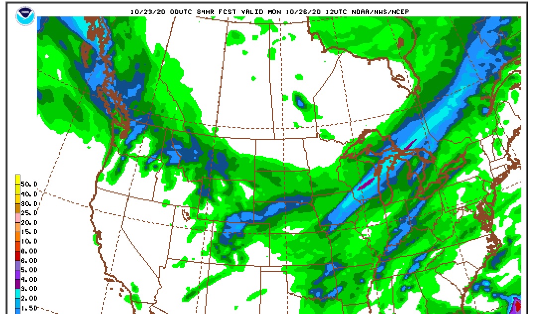
The next storm system will begin to affect our weather Saturday night. Much colder and moist upslope flow will become established in northeastern Colorado. Freezing drizzle will give way to light snow, and this snow should continue into early Monday morning. The amount of precipitation we will see with this complex storm system is up in the air. The latest NAM model run puts out somewhere between 0.75 and 1.0 inches of liquid in Nederland with up to 1.5 inches up toward Estes Park and Rocky Mountain National Park. Given a 1:12 snow ratio, this would leave us with 8 to 12 inches of snow, with up to 18 inches north of us:
The GFS is not quite as bullish and seems to be focusing more of the storm’s energy to our south:
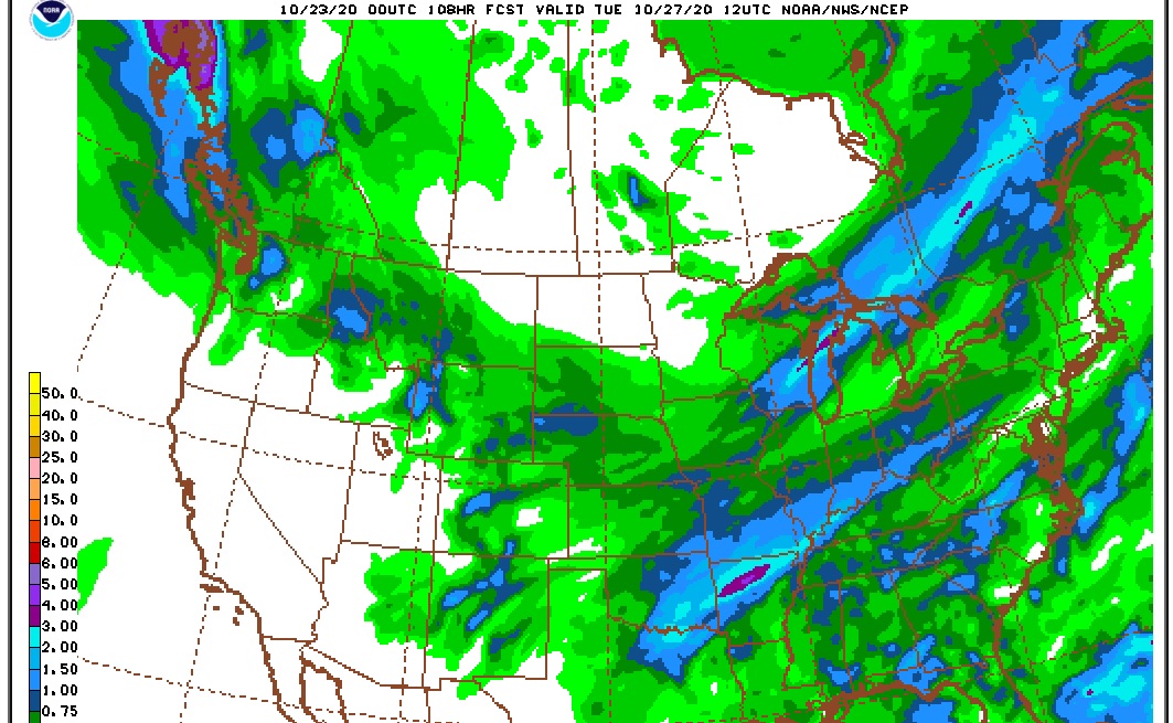
This gives us about 0.50 inches of liquid which translates to about 4 to 8 inches of snow.
DarkSky continues to put out insane snowfall amounts for Ned – 15 to 24 inches. Weather Underground has consistently been calling for around 10-12 inches.
The problem is that the models are struggling with the structure of this storm. It appears that its energy is going to split with most of it sinking southwestward into the southern Great Basin. In order to get moderate to heavy snowfall here in Colorado, we need a source of lift. We will be positioned in favorable position with respect to the upper level jet stream, and this can result in bands of heavier snowfall, but it takes a lot of lift when you are dealing with cold dense air. In my experience, the GFS tends to deal with the structure of storms in the Central and Southern Rockies better than the NAM does, particularly when the event is several days off.
So, for now, I am leaving my forecast at 4 to 8 inches for Nederland and the surrounding Foothills communities. Any precipitation is better than nothing at this point. Look for lows Sunday night to be near 0 F. Details on this storm should become clearer Friday night and Saturday. I’ll keep you posted.