The past few days have continued to see conditions conducive to extreme fire growth in Northern Colorado. There are five fires currently burning within 50 miles of Nederland, Colorado. The closest one, the Left Hand Canyon fire, is only about 5 miles from Ned as the crow flies. Taking a quick look at my records, the snow storm on September 8-9th was the last significant precipitation event we had. In fact since that storm, I have only measure 0.03 inches of precipitation. We’ve basically had 45 days of almost no precipitation, and we were dry to begin with.
Big changes are coming for our weather starting with a strong cold front which will push through Northern Colorado Thursday afternoon. Behind this front temperatures will plummet into the upper 20s F, and there could even be a few snow showers. Friday morning’s lows will be in the upper teens with temperatures rebounding into the 45-50 F range by the end of the day. Saturday will be another challenging day for firefighters. It will be warm and windy wth highs reaching into the mid 50s F. The winds will be ahead a strong storm system that will swing across the Central and Southern Rockies Saturday night through Monday. This storm will bring much colder air and snow to Nederland and the surrounding Front Range Foothills communities. Starting with what we are most certain about – it is going to get very cold. It looks like highs on Sunday will only be in the teens F with lows Sunday night dropping into the 0-5 F range.
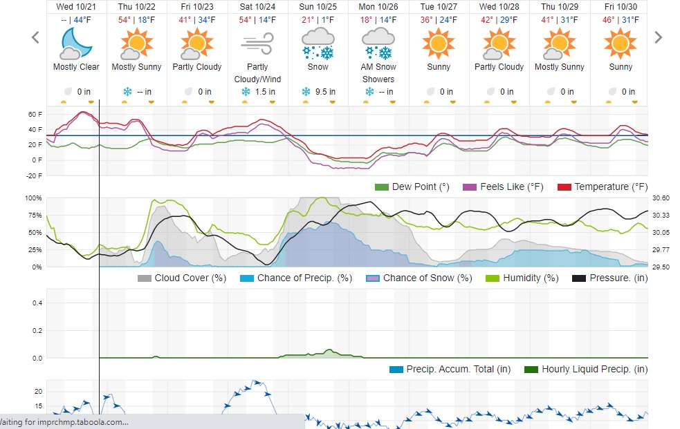
As I mentioned, there will be snow too. This will likely start Saturday night and continue into early Monday. How much precipitation we will receive is much less clear. This is a complex storm system, and it looks like the energy associated with it will spit between a low diving into the southern portions of the Great Basin and a trough digging into the Central and Southern Rockies. The model ensembles are favoring the energy with this storm splitting. This usually means that there will be less forcing available to produce precipitation in Northeastern Colorado. I’ve been watching the models, and they are generally putting out 0.25 to 0.50 inches of liquid in and around Nederland. Given that this storm will be cold and snow ratios should be at least 1:15, this would result in a 3 to 7 inch snowfall.
Weather Underground is forecasting about 11 inches for us while Dark Sky is the outlier putting out nearly 20 inches. I really don’t know how Dark Sky comes up wth its forecasts, but it is always entertaining to look at.
Given all of that, my current forecast for the weekend storm is for 4 to 8 inches of snow. Obviously, this event is several days off, so things can change.
Here is the Weather Underground forecast: