The cold air inversion held strong on Friday in the Colorado Front Range Foothills, and it was not until the end of the day that the sun made an appearance in Nederland. Temperatures reached into the low 20s F during the afternoon after a cool start around 9 F. As of 9 PM Friday evening at our home in Ned, the clouds are gone and the westerly winds are starting to blow. These winds will continue to blow strong and gusty at times through Saturday with temperatures climbing into the 55-60 F range. Critical fire weather conditions will be around for one more day before a winter storm settles into Colorado.
We are still on track for bitter cold and snow starting Saturday night and continuing into Monday morning. Exactly how much snow will fall is still up in the air. What has been interesting is that each model is holding strong to it’s solution. I am not certain how Weather Underground and DarkSky generate their snowfall forecasts but they have been consistent. Weather Underground is still calling for about 12 inches while DarkSky is still calling for around 18 inches (the range is 13-21 inches). The National Weather Service has issued a Winter Storm Watch for us for 8 to 14 inches. The NAM and ECMWF are generating higher precipitation totals for us while the GFS is much lighter.
Here is the very latest NAM precipitation forecast for this storm:
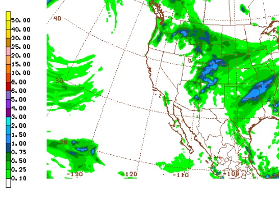
This is putting out nearly 1.5 inches of liquid from Nederland up to Estes Park. With a 1:15 snow ratio this would translate to almost 22 inches of snow. The 18z GFS is only putting out 0.25 inches to 0.50 inches of liquid. That would leave us with only 4 to 7 inches of snow.
What’s the difference? The models seem to be agreeing that the energy associated with this storm will split, with a cut-off low dropping into the southern Great Basin a long way from us here in northern Colorado. This is not generally a good pattern for a big Front Range snowstorm. What some of the models seem to be latching on to is strong lift associated with jet dynamics. The NAM has us square in the right rear entrance region of an upper level jet on Sunday morning, and we stay there for much of the day:
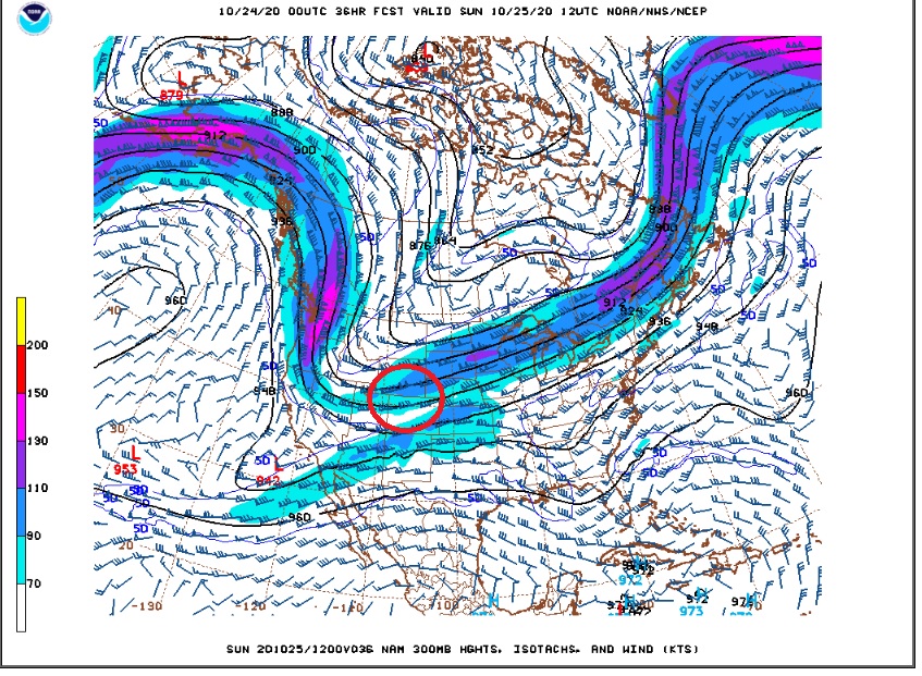
Ageostrophic circulations around the entrance and exit regions of jet streams can indeed enhance life and precipitation. The NAM is showing vertical velocities in excess of -6 microbars per second which is pretty good for a winter time situation. The thing about jet enhanced precipitation events is that they tend to be banded in nature. That is, the bands of heavier precipitation tend to align themselves with the axis of the jet streak, in this case from southwest to northeast. These bands can be narrow, and pinpointing there exact location is difficult. The GFS wants to keep these bands of heavier snowfall farther to our south while the ECMWF and NAM keep them more in northern Colorado. Where these bands se up, there can be a lot of snow. A few miles away, the amounts can be much lighter.
There is a lot of uncertainty in the models, but I am going to up my snowfall forecast to 6-10 inches. I think that there is enough data to support at least these amounts.
Here is a really cool thing! As of 10:30 PM the temperature at out home 4 miles east of Nederland is 25 F. The temperature in Nederland is almost 50 F!! The cold air is eroding out: