This past weekend featured topsy turvy weather along the Front Range foothills of northeastern Colorado. While Nederland enjoyed some relatively mild temperatures and sunshine on Saturday and again on New Years Day (Monday), much colder air and clouds remained entrenched along the plains. Locations such as Boulder, Broomfield, Superior, and even Denver saw daytime temperatures struggle to get out of the teens while in Ned we reached the mid to upper 40s at times. If you drove from Ned to Boulder or vice versa you noticed the much colder temperatures, clouds, and flurries on the plains. What’s up with that? Doesn’t it normally get colder the higher you get in the mountains.
The short answer is, “yes, most of the time.” Unless there is an inversion. A what? When warmer air sits over colder air in the atmosphere, the result is an inversion where locations such as Boulder can be much colder than mountain towns such as Nederland. There can be several different causes of this. The inversion we saw this past weekend was the result of a shallow pool of cold air pushing into northeastern Colorado, reaching down to about the Palmer Divide. This pool of air was less than 1000 feet thick and was capped by a layer of clouds which helped to block the sun and its heating.
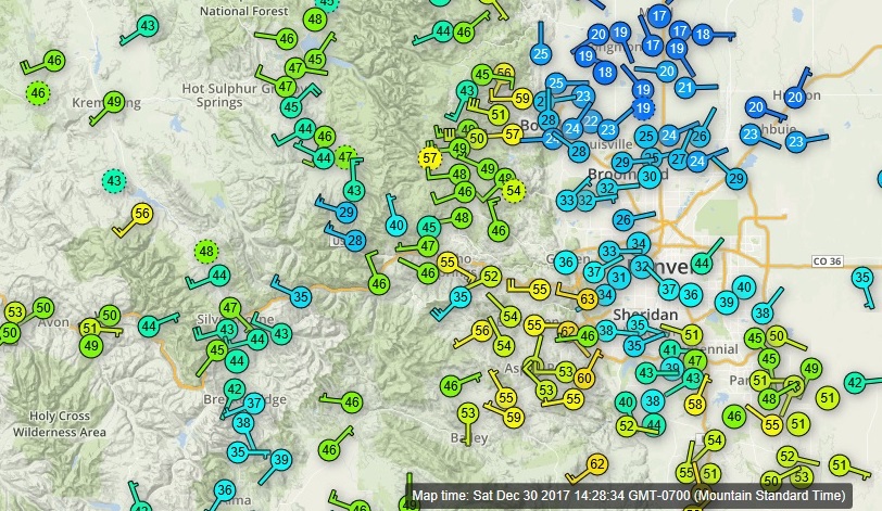
This map of temperatures reported by Weather Underground stations was captured on Saturday afternoon. Notice the much cooler temperatures on the plains while foothills communities are showing much warmer conditions. Also notice the difference in wind directions. The wind direction on the plains is predominantly from the east northeast while in the higher terrain they are from the west.
A disturbance did help to push more cold air up along the east side of the Continental Divide Saturday night and Sunday. During this time, temperatures plummeted 15 – 20 degrees in Nederland, and an inch or so of new snow fell. By New Years Day, the cold air retreated from Nederland, but remained entrenched in the Eastern Plains.
As of this writing Monday night, easterly winds have once again pushed cold air into Ned.
The low winter sun angle combined with a snow pack in areas on the Eastern Plains can make it difficult to warm up the shallow cold air masses associated with inversions and thin layers of stratocumulus clouds can make it even harder. During these inversions, pollutants can get trapped closer to the ground reducing air quality.
The inversion is expected to break this week and milder temperatures should return to much of northeastern Colorado. Until then, enjoy this topsy turvy atmospheric phenomenon.