A piece of energy in the upper levels of the atmosphere swooped through Colorado on Friday bringing snow to the mountains and Foothills and a quick shot of colder air. I measured 3.3 inches here at our home east of Nederland, Colorado, with temperatures dropping to 4 F. This same piece of energy has moved on to the southern United States and will create a much larger storm for the East Coast on Sunday and Monday.
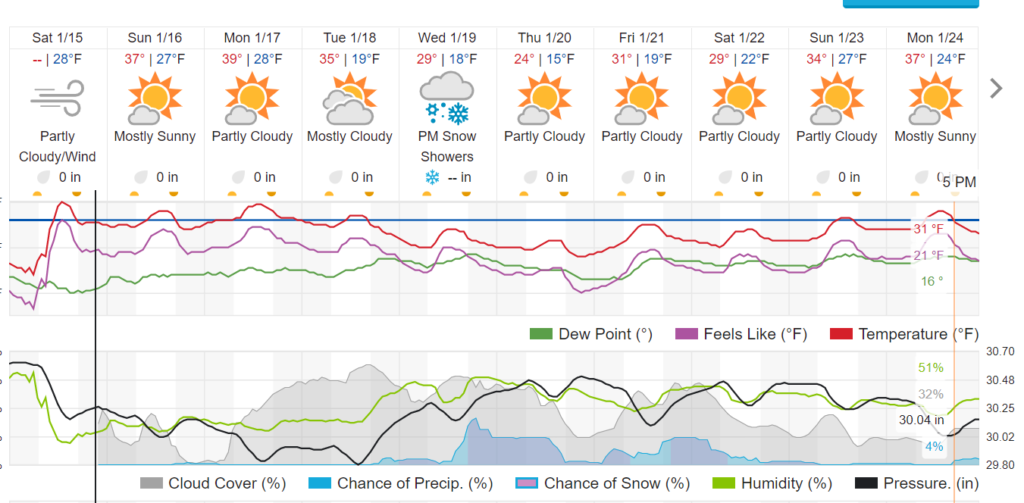
The weather for the week ahead will be relatively quiet for us here in the Front Range Foothills. A typical pattern for January, we will see a ridge in the western United States with a trough in the East early in the week. By Wednesday this ridge will retrograde to a position off of the West Coast as colder air filters down into the middle of the country. This means that temperatures will be cooling down for us as the week progresses. On Sunday and Monday highs in Ned will be in the 35-40 F range. By Wednesday and Thursday highs will only be in the 20s F. This seasonably cool weather is then expected to continue into next weekend.
Not much in the way of precipitation is forecast over the next several days. A strong cold front on Wednesday could generate enough upslope flow to generate a few snow showers in the Front Range Foothills, but little in the way of accumulation looks likely right now.
We are now at 33.7 inches of snow for the 2021-2022 season which is well below our normal of 53 inches for this time of year. The storms we have had over the past few weeks have helped, but we are still in drought.
Here is the forecast from Weather Underground:
