Thursday’s storm left 12.2 inches of snow at our home east of Nederland, Colorado. This is the second largest January snowfall in my records which go back to July 2010. The top January snowfalls in records include:

January is normally our driest month of the year. It is not surprising that we have not had many big storms as compared to the fall and spring. In my 13 years of records, there have not been too many January snowfalls even greater than 6 inches.
Overall, this storm performed close to the forecast. The northern mountains of Colorado received the brunt of the snowfall with Steamboat and Winter Park seeing some of the largest totals. The Indian Peaks and Rocky Mountain National Park had totals close to 2 feet, at least according the Snotels:

The total liquid with this storm was 0.78 inches, and this with 12.2 inches of snow results in a 16:1 ratio. This is a decent amount of moisture, and the north-facing sides of ridges should hold on to their snowpack for at least a few weeks to come.
The big surprise with this storm was the very cold temperatures Thursday night. We got down to -8 F, much colder than the forecast 15 F minimum temperature. The cold air settled in east of the Divide much quicker and more strongly than expected.
The moisture of the past few weeks is welcome, but we will need much more to eradicate the drought we are experiencing. The Drought Prediction Center has us in extreme drought:
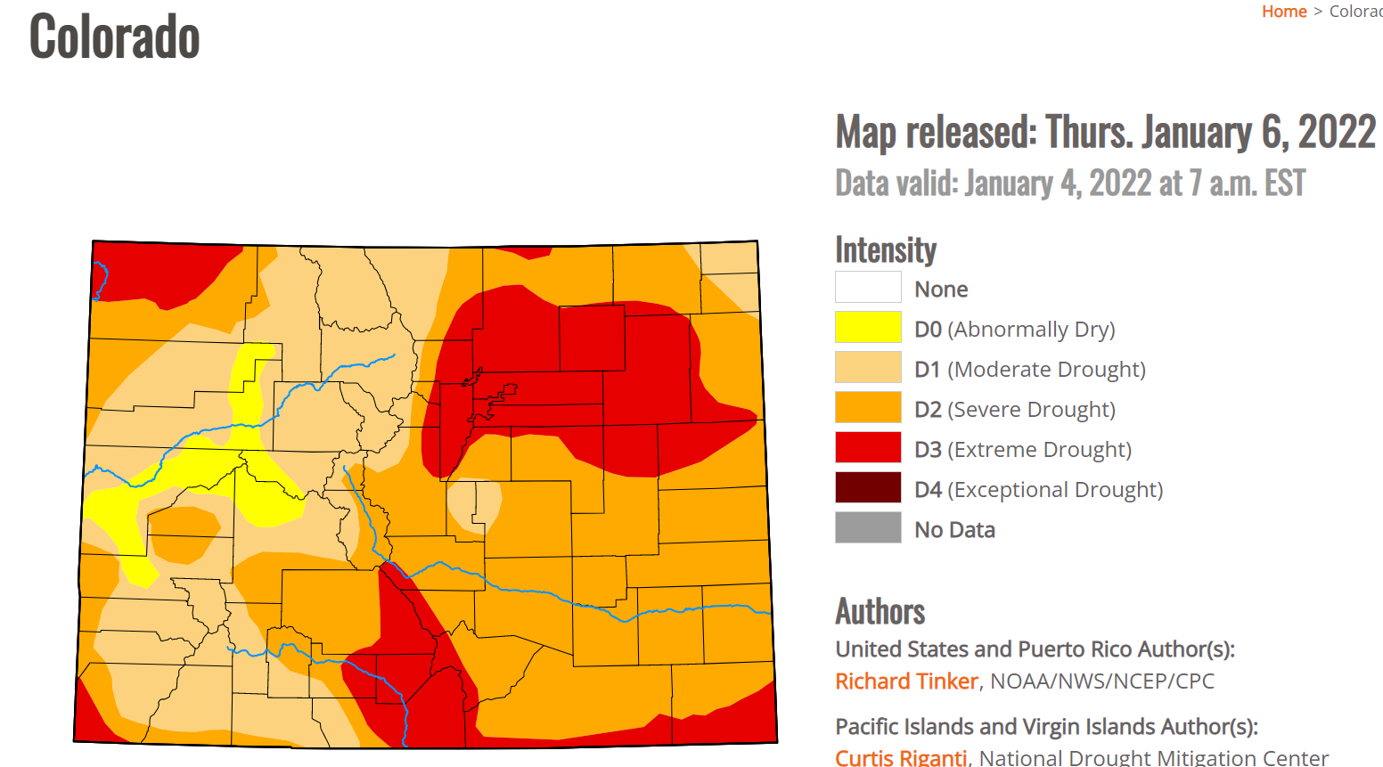
This map was made before Thursday’s storm. We’ll see how much improvement there is on next week’s map.
Tranquil and milder weather will return this week. A ridge will build over the Western United States this week pushing the storm track well to our north and pushing our temperatures to about 10 degrees above normal by Wednesday. Highs in Nederland will be approaching the mid 40s F mid-week. In is not unusual to have a January thaw, but temperatures for much of this winter season has been way above normal. December was over 6 degrees warmer than normal for us, which is unprecedented in my records.
A weak storm system will bring a chance of snow and colder temperatures on Friday.
Finally, here is a quick look at where the various river basin headwaters are at in terms of precipitation so far this season:

Surprisingly, the recent storms have pushed the snowpack water equivalent in the northern and southwestern mountains of Colorado to above normal levels. The South Platte River Basin – the one Nederland is in – is at 131 % of normal. It is still relatively early in the snow season, but this is a welcome sight.