The storm this past Sunday and Monday left 14.5 inches of new snow at our home in Nederland, but it definitely was a piddler. Although it snowed on and off for nearly 48 hours, there were times where the sun broke through the clouds. For much of the storm, the snowfall rate was well under 0.5 inches per hour. Measuring snowfalls like this is challenging because the snow pack has plenty of time to settle. Big spring snow storms can bring some impressive snowfall rates. In the 10 years we have lived here, I have observed over 30 inches in a single day. While this system was not a heavy hitter, it was cold. Our low Monday morning was 3 F. Did someone forget it is spring? Here is the snowfall map for our area. Notice that Boulder County saw some of the higher amounts. My forecast of 10 to 14 inches was just a smidge low:
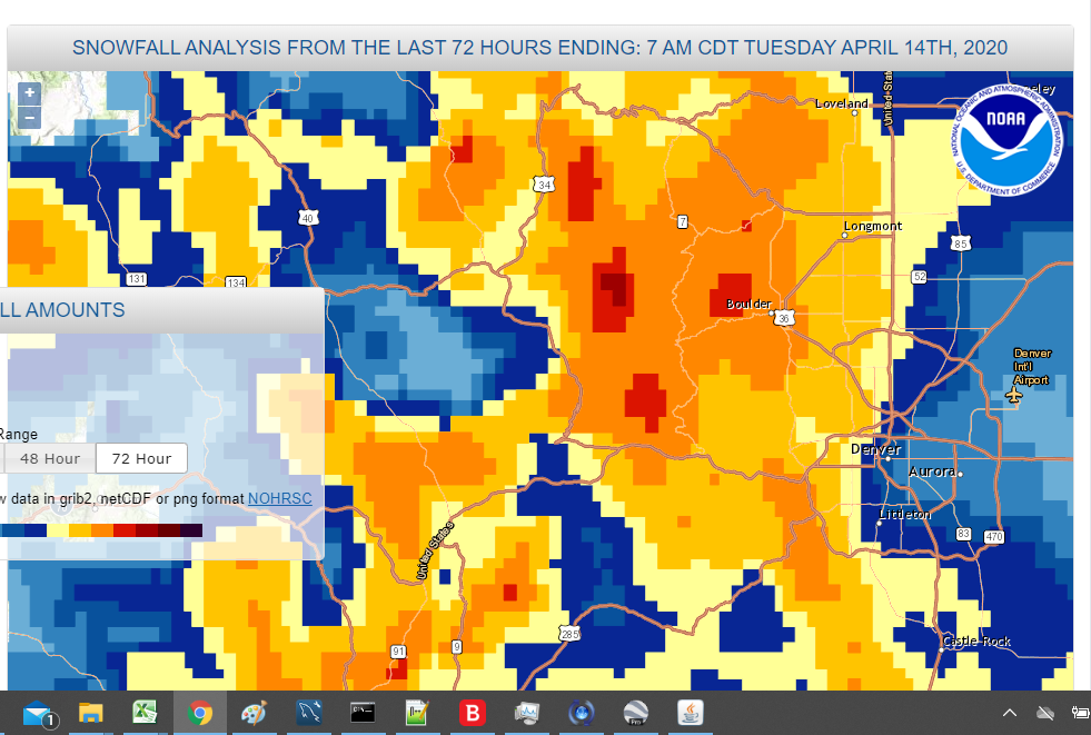
The orange is 12 to 18 inches with 18 to 24 inches in a few isolated spots.
We are in for another round of snow Wednesday night and Thursday. As usual, we are expecting a strong cold front to sag southward over Colorado Wednesday night with moist northeasterly upslope flow bringing snow on Thursday to the Front Range Foothills and Mountains. As seems to be the norm around here, the forecast is never easy. Models were consistely showing a 10 to 15 inch snowfall, but the runs earlier today had backed off a bit, making it more of an 8 to 12 inch snow event. However, I just took a peek at the latest GFS model precipitation totals, and it is putting out nearly 1.50 inches of liquid here in Nederland. This would amount to a 17 to 22 inch snowfall depending on snow ratios, which I expect to be around 14:1.:
This is a significant shift southward in the storm track as well.
This next storm system will be about 10 F warmer than Sunday’s storm. We will not have the extreme record breaking cold we saw on Monday morning with temperatures for the bulk of the upcoming storm in the 15 to 20 F range.
This is the first run of the GFS that I have seen so bullish with the precipitation. For that reason, I am going be skeptical and stick to the current 8 to 14 inch concensus forecast. If the GFS remains this aggressive in tomorrow morning’s run, I will post an update. Either way, we will see a return to cold and snow for the end of this week. On the bright side, the cold will be short-lived. Temperatures this weekend should rebound in the 45-50 F range.