The cold front which swept through the Colorado Front Range Foothills on Monday has ushered in much cooler temperatures, and this taste of autumn will remain through the balance of this week. In addition to that, there will be enough moisture available to result in some precipitation,especially Wednesday night into Thursday night. During this time, Nederland should see a few periods of light snow. However, the ground is still warm, and this will limit accumulations to perhaps a light dusting on grassy surfaces in the Front Range foothills. A few inches of snow is expected in the higher elevations of the Indian Peaks. This is just a reminder that winter is not too far off. Daytime temperatures will only be in the low to mid 40s through Thursday with lows dipping into the mid 20s. That will be enough of a freeze to kill garden vegetation, flowers, and most importantly those pesky thistles and mulleins which line area roadways. However, just in time for the weekend, temperatures will moderate. If you are lucky enough to have Columbus Day off, your long weekend will be spectacular with plenty of golden Colorado sunshine. Just another reason why we live in Nederland!

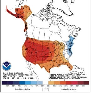
Unfortunately, at least for the Ned snow lovers, this cool weather will be short-lived. The Climate Prediction Center’s 6-10 outlook which shows temperature trends for next week indicates a return to above normal temperatures.