Today’s storm brought very strong and gusty winds to the Colorado Front Range Mountains and Foothills as well as the Eastern Plains. I measured wind gusts up to 60 mph at our home here in Nederland, Colorado, but reports of 70 to 80 mph gusts were common around the area. In addition to these winds, a strong squall line blew from west to east over the Foothills and Plains this morning. If you were up around 7 AM this morning, the sky looked ominous, almost pitch black over the Indian Peaks and Front Range Mountains. Here in Ned, from about 7:15 AM to 7:45 AM, it snowed hard leaving a quick 1.4 inches of new snowfall. Then the winds kicked in, and a lot of that snow blew away. A quick look at the SNOTELS in the Indian Peaks shows about three inches of new snow around the Brainard Lake area with between 8 to 12 inches of snow now on the ground.
With the snow, wind, and cold it truly felt like winter today. And that will be about it through the end of the month.
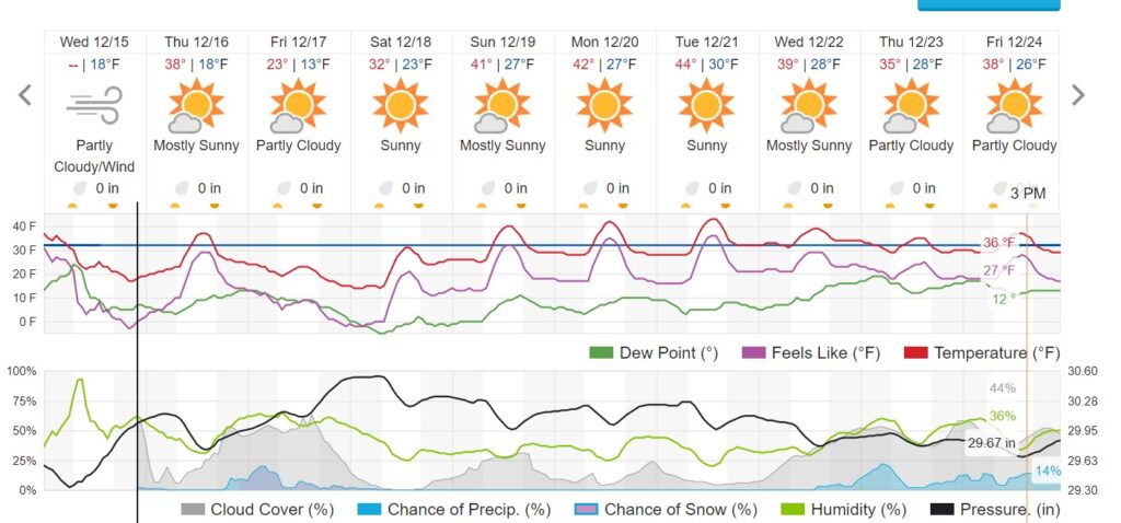
There are no storms in sight for Northeastern Colorado, particularly east of the Continental Divide. Temperatures over the next several days will be seasonable, but it will be dry. Here is the WeatherUnderground forecast:

That is a lot of sunny but dry weather. I’ll summarize our temperature and snowfall standings at the end of this month. Suffice it to say, these don’t look good.