January is the driest month of the year here in Nederland and the surrounding Front Range Foothills communities. At my location, which is about 4.5 miles east-northeast of Ned, we have averaged only 0.6 inches of liquid precipitation over the past 7 years, and that translates to a monthly average snowfall of 12.4 inches. Most snowfalls in January also tend to be relatively light along and east of the Continental Divide. Over the past 7 years, the largest January storm I have recorded is 9.4 inches on January 4-5, 2014. A big reason for the lack of substantial snowstorms in January is the lack of moisture to produce snow. Cold air masses shift southward across the Great Plains, effectively cutting eastern Colorado off from the Gulf of Mexico, a prime source of moisture for those mammoth spring snowstorms which can cripple the Colorado Front Range. Moisture from the Pacific Ocean tends to get “wrung” out of the atmosphere by the many mountain ranges between us and the West Coast. It is common in January for locations on the plains near the Foothills – such as Boulder and Broomfield – to get more snow than Ned because upslope flow is weak and the best snow growth temperatures are lower than us.
With all of that said, it looks like Nederland is in for a decent sized snowfall over the next few days, especially considering that it is January. In the weather business, it can be difficult to qualify snowfstorms. When I lived in Washington DC, a snowfall of 12 inches would be considered large and would shut schools and government facilities down for days, with everything coming to a standstill before the first flake of snow touched the ground. Out here in Ned and more generally in Colorado, it is life as usual when snow falls except that people call in sick and go skiing.
A couple of key atmospheric ingredients are coming together on Wednesday and Thursday to bring snow to our backyards:
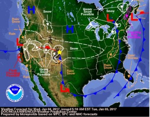
- A cold front has stalled across Colorado (it has become a stationary front)
- A large amount of moisture is streaming into Colorado from the western United States. This same moisture will result in snow amounts of 6+ feet (yes that’s feet) in the California Sierra Nevada mountains, and this time there is enough moisture to bring snow to us as well.
- A strong jet stream in the upper levels of the atmosphere will enhance lift and snow production over northern Colorado
This is a slow moving system, and precipitation will be enhanced along the stalled front, as the NOAA forecast map below shows:

Note that there will not be a strong surface low or much wind, so blowing or drifting of snow will not be a major problem. However, the roads are cold and will quickly ice up. Some dirt roads around Ned still have ice on them from the last storm and will become very slick Wednesday and Wednesday night.
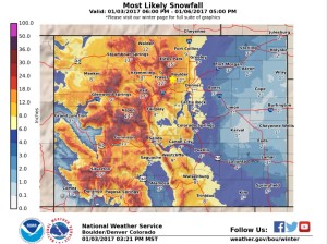
I’m including a link to the National Weather Service’s snowfall probabilities page for northeastern Colorado.
National Weather Service Snowfall Probability Page
The image below is the most likely snowfall forecast from this site, but check this site often for updates. Totals in Nederland are forecast to be in the 12 to 18 inch range. The main concern I have is the lack of strong upslope flow. Sometimes, in these colder storms the heavier snow often falls in the lower foothills between Nederland and Boulder.

I’ll post an update tomorrow. Stay safe on the roads!