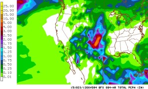
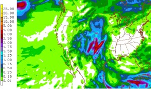
Our streak of pleasant autumn days with above normal temperatures will come to an abrupt end by the middle of this week as a deep upper level storm system slowly tracks across the desert Southwest to a position over Arizona by Tuesday evening. This storm will then slowly lift northeastward over Colorado Wednesday and Thursday. While this storm will bring precipitation to many parts of Colorado, it will be the first upslope storm of the season for the Front Range. Its slow motion will allow it to tap ample moisture from the Gulf of Mexico, and the upper level dynamics should help to enhance the upslope. The bottom line is plenty of rain for the Northeast Plains, Foothills, and Nederland. Why not snow? Snow levels with this storm will start high around 12000 feet and lower to 9000 feet by Wednesday. While Ned may see some snow mix in with the rain on Wednesday, accumulations will be limited to the mountains. Temperatures will not get out of the 30s on Wednesday, so bundle up if you head outdoors. The 00z models have come in a bit wetter:


As with all storms which affect the Front Range, any slight changes in track or strength can result in significant changes in the forecast. Stay tuned. We’ll keep an eye on the snow levels.
Tuesday: Becoming mostly cloudy with a chance of afternoon showers. High 58.
Tuesday Night: Rain, possibly mixed with snow towards morning. Low 34.
Wednesday: A mixture of rain and snow: High 38.
Wednesday Night: Cloudy with occasional rain, possibly mixed with snow at time. Low 34
Thursday: Mostly cloudy with showers, High 44.