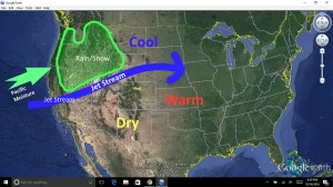
No, it’s October. But it will feel like late September this weekend and early next week as Nederland’s winning streak of stupendous weekend weather continues. Afternoon temperatures will flirt with 70 F with morning lows in the mid 40s. Sunshine will mix with high wispy cirrus clouds at times, making for some great photo opportunities at Brainard Lake. However, these clouds will not produce any precipitation. Warm and dry succinctly summarizes the weather in the Front Range foothills over the next several days. The jet stream, the strong ribbon of winds in the upper levels of the atmosphere which steers storms and often separates colder air to the north from warmer air to the south will remain north of Colorado through Sunday leaving us mild and dry. At the same time, moisture-rich Pacific air will continue to bring rain and high elevation snows to the Pacific Northwest and Northern California. This moisture-laden air will not make it into the Front Range. The only sign of this moisture in our forecast will be some occasional high cloudiness mixing in with copious amounts of sunshine.

By late Monday of next week, the jet stream will start to sag southward across Colorado. As it does, cooler air will filter into the region. At this point, not much in the way of rain or snow is expected with this cold front. However, we will need to keep an eye on the winds which could be strong and gusty Sunday and Monday.