The Climate Prediction Center puts out a weekly update on the status of the El Nino Southern Oscillation (ENSO). It includes La Nina (cold phase ENSO) and El Nino (warm phase ENSO) forecasts for the next year. As with any long range forecast product, a lot can change over a few months. However, as we close in on the winter season, the odds of there being an El Nino are still favorable:
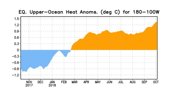
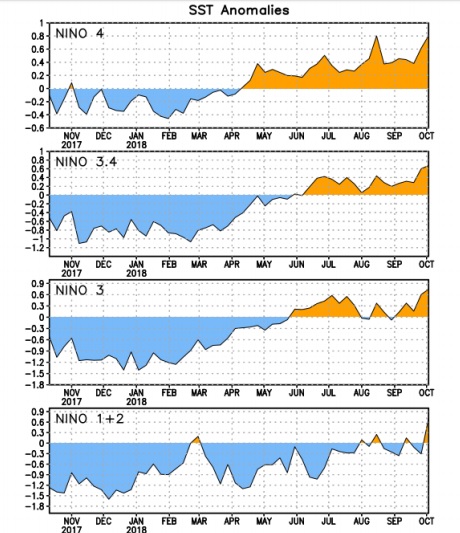
One measure of an approaching El Nino is to track the temperature of the water in the equatorial Pacific and compare it to long term averages. The diagram above shows the warming trend over the past 6 months in these waters, which can be an indication of a developing warm phase ENSO. There are also several indices that are used to monitor the sea surface temperatures of various portions of the equatorial Pacific. These include the 1+2, 3, 3.4 and 4 indices. Typically, the 3.4 index is used when monitoring for ENSO, but all of the indices are showing a trend towards warmer waters, particularly in the eastern equatorial Pacific where El Ninos form.
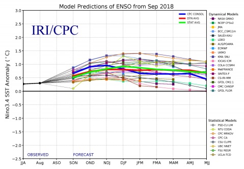
Finally, there is a set of climate models that are used to predict ENSO events. These are plotted in an ensemble format and attempt to predict the ENSO 3.4 temperature anomaly. Note that an ENSO 3.4 value between -0.5 and 0.5 is considered a neutral phase ENSO. A value smaller than -0.5 is considered to represent a La Nina. A value larger than 0.5 is considered to be an El Nino. Notice that most models are predicting a weak to moderate strength El Nino this winter:
What does that mean for Nederland? El Nino influences the storm track across the United States. It typically results in a stronger wintertime subtropical jet stream across the southern United States. This results in a greater chance for rain and snow in these areas. For the Colorado Front Range, there are enhanced chances of fall and spring snow storms, particularly the large upslope storms that can paralyze our area with feet of snow.

It remains to be seen what happens this winter, but all of our El Nino winters so far on my records have yielded normal to above normal seasonal snowfalls, anywhere from 155 inches to almost 200 inches of snow in the strong El Nino year of 2016. Stay tuned!