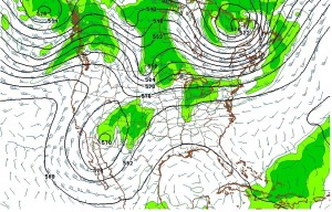
The American and European models are in general agreement that a trough will slowly dig southward over the West coast over the next few days eventually forming a deep low in the mid levels of the atmosphere over far southern California/western Arizona on Tuesday. This will be a slow moving system, giving it time to pull in (or “entrain” in weather lingo) Pacific and Gulf of Mexico moisture. That combined with low and mid level winds coming from the east on Wednesday could result in some significant precipitation along the Front Range mountains and nearby plains. Unfortunately, this storm is warm, and as a result snow levels will be high, probably above 10000 ft. The forecast models are notoriously poor at forecasting the tracks and speeds of these “cut-off” lows. One reason for this is that these lows are separated or “cut-off” from the steering winds of the jet stream. They have a tendency to want to retrograde or move westward instead of eastward. The sum of all this is that these storms can move in unpredictable ways, making for a tough forecast. The image below shows this low at 500 mb (or around 16000 ft) on Tuesday evening:

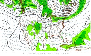
This image of the 700 mb heights and humidity shows plenty of moisture over Northeastern Colorado midday Wednesday with upslope winds from the east-southeast:

The storm will reconnect to the jet stream and quickly move northeastward over Colorado and into the Northern Plains on Thursday. Right now, it looks like the most precipitation will occur on Wednesday.
Sunday: Morning sun mixed with high clouds. A few showers will build over the Divide during the afternoon bringing a chance of a little rain in Nederland. High 63 F
Sunday Night: Isolated showers giving way to a partly cloud sky. Low 40 F
Monday: Partly sunny with a chance of afternoon showers. High 60 F
Tuesday: Intervals of clouds and sun, with a chance of showers. High 58 F
Wednesday: Cloudy with rain possible, chilly, High 44 F.