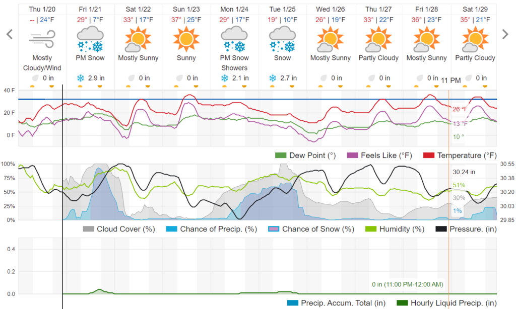
The forecast models have been consistently showing a quick shot of snow for Nederland the surrounding Front Range Foothills communities Friday afternoon and evening. The latest GFS and NAM are showing somewhere between 0.10 and 0.25 inches of liquid which with a 15:1 snow ratio would result in 2 to 4 inches of new snow.
An upper-level storm system will dig southward into the Great Basin on Friday eventually forming a cut-off low over southern Nevada by evening. This is not a spectacular set-up for snow in the Colorado Front Range. However, a strong cold front will sweep southward through our area midday Friday, and the combination of moist upslope northeasterly flow behind this front and some upper-level lift will result in a 5-to-6-hour period of light snow. The NAM 700 mb map for Friday evening shows the deep storm centered well to our west, but it also shows some geostrophic lift, moisture, and northeasterly winds. Temperatures should support good dendritic growth, and this will allow us to squeeze accumulating snow out of an otherwise mediocre precipitation event:

The NAM Skew-T shows decent upslope flow by Friday evening, with northeast winds up to 25 kts:

Here is the official National Weather Service snowfall forecast:

And here is the forecast from Weather Underground:

If you remember, we had a smallish snowfall last Friday, but it was enough to make roads slick. Since this storm will also be occurring around the evening rush hour, I suspect area road conditions will deteriorate.
Looking ahead, yet another storm is possible early next week! More on that in another post.
Surprisingly, many of the mountains in Colorado, including the Indian Peaks, have received above average snowfall this season. They’ve made up a lot of ground in January:
