The North American Model (NAM) continues to be very aggressive with snowfall along and east of much of the Continental Divide in Colorado. It continues to be the outlier, but it is worth noting that the latest run of the GFS is also coming in slightly wetter this evening. One of the computer generated products that meteorologists sometimes look at is the model output statistics (MOS). The NAM MOS is very interesting this evening:
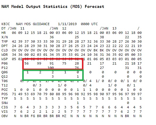
It is showing a 100% chance of precipitation tomorrow (the red box) with upwards of 0.75 inches of liquid precipitation (green box). It is not often that a MOS product produces a forecast with a 100% probability.
The NAM is probably over doing this forecast, but the potential is there for a decent snowfall for Nederland and the surrounding foothills communities. For now, I will stick with the consensus forecast of 4-6 inches for our area, but I would not be surprised to see locally higher amounts particularly in locations between Boulder and Nederland on east facing mountain slopes.
This will not be an extremely cold storm – look for temperatures in the low to mid 20s on Friday, and the snow may last into Saturday night along with brisk northeasterly winds. It will feel like winter a day after temperatures where in the mid-upper 40s in many areas.
Stay tuned!