The temperature at our home east of Nederland dropped to -21 F on Sunday morning. This is the fourth lowest temperature in my 11 years of records:
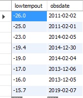
It is also the lowest temperature I have measured since February 2, 2019. It has not been below -20 F here since February 5, 2014, just a little over 7 years ago. It does not get this cold too often here in Nederland. Also, the high on Sunday was only -5 F. This is the second coldest maximum temperature in my records, the lowest high being -11 F on February 1, 2011!!
My (and most other) snow forecasts left something to be desired. There was the surprise 7.4 inches on Friday night. Then the forecast for 4 to 6 inches on Saturday night was a complete bust – I only measured 1 inch. It is tough to get a decent snowfall when it is so cold. Also, it looks like much of the energy with Saturday night’s storm went south of us.
What was likely the coldest weather of the season is on the way out. As I write this on Sunday night, the temperature has risen to -7 F. Despite this we probably will not see a high above 32 F until Friday.
The next real chance of precipitation will be on Wednesday afternoon and evening. The models are showing some weak convergence over the Front Range Mountains as a trough pulls way from us eastward into the Plains. Any snowfall shoud be light and on the order of an inch or two. Beyond that there are still no big storms in sight for us. We need to hope that we get some juicy spring snowstorms. Otherwise, we will be high and dry going into the early summer.
Here is where this year’s snowfall ranks against other years through February 14th:
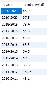
We are currently rank as the third least snowiest winter since 2010. Let see what happens in the months ahead.