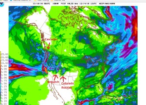
This West Side Story does not take place in Chicago. It will occur on the west side of the Continental Divide over the next week as a series of storm systems laden with Pacific moisture track across Colorado. Even though they will be crossing several mountain ranges between the Colorado Front Range and the West Coast, they will still have ample moisture to produce alot of snow in areas along and west of the Continental Divide. Areas east of the Continental Divide, including Nederland and the surrounding foothill communities will receive a little snow as it blows over the Divide, but for the most part these areas will be “downsloped”. As the winds blow over the Continental Divide and descend toward the Colorado plains, they will dry, causing precipitation to diminish. Nederland will see some windy days with some passing snow showers, but accumulations will be generally light. Areas west of the Divide, on the other hand, such as Winter Park may see over 2 feet of snow. This is good news for many of the Colorado ski resorts which have experienced a slow start to this ski season.
This is a map of the total precipitation forecast from the GFS, one of the medium to long range weather forecast computer models used by meteorologists. It nicely shows the enhanced precipitation as the storms pass over the mountain ranges of the West.
