November in Nederland can feature a variety of weather. Significant snowfalls have occurred around Election Day, making it challenging to get to the polls to vote. Not this year. In fact, the same weather we have been experiencing for the past few months – warm, sunny, and dry – will prevail over the Colorado Front Range through the weekend. The upshot of all of this – you can’t use weather as an excuse for not voting. Nope. The roads will be dry and passable.
One of the things that makes weather so fascinating is how different it is from year to year. Last November was cold and snowy on this date. This year, we are looking at drought and unseasonably mild temperatures. Our region has been mired in a blocking pattern which has forced the storm track well to the north of the Central Rockies. When the storm track is north of us, it usually means that the cold air is trapped well to the north of us as well. That leaves us high and dry.
I’ve talked alot about blocking patterns in these posts. They often manifest themselves in the mid and upper levels of the atmosphere where the winds are sometimes called ‘steering winds’ – the jet stream falls under this category. These winds steer the movement of storms. It gets complicated fast. Storms move warm and cold air masses, the warm and cold fronts you would see on the evening news weather map. The movement of these air masses causes the steering winds to shift which causes the storm track to shift which causes the movement of air masses to change. In short, there is alot of what I call ‘chicken and egging’ in meteorology. Cause and effect gets hard to discern. The main point to take away from all of this is that forecasting the weather and movement of storms can be tough, because there are an inordinate number of influences on storm movement.
That gets a little simpler when you are stuck in a persistent weather pattern, like we have had now for a few months. A forecast of warm and dry weather for the next several days is much easier to make when it has been warm and dry for several weeks. Persistent weather patterns can be stubborn, and computer weather forecasting models really suck at predicting when and where they will break down. For us, if you enjoy winter sports, this is not great news. If you like hiking and mountain biking. Well … conditions are terrific. All of us in the Front Range foothills are holding our breath as the fire danger is much higher than is normal for early November.
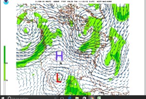
This image below illustrates that we will be under a text book Rex block over the next several days. This is a map generated by a computer weather forecasting model. It shows the winds and storm system positions at about 25000 feet on Thursday afternoon. The key take-away is the juxtaposition of the high (big blue ‘H’) over Wyoming and Montana and the deep low (big red ‘L’) over northern Mexico. Nederland is located under the black ‘N’ between these systems. This positioning of a high and low in the mid levels of the atmosphere is very stable and will result in more of the same for us … dry, dry, dry.
